Research
Ongoing
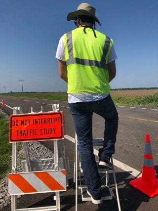
Statewide Seat Belt Use Survey
 Sponsored by the Arkansas State Police, Highway Safety Office
PI: Sarah Hernandez
This project examines statewide seat belt use in Arkansas in compliance with the National Highway Transportation Safety Administration (NHTSA) Seat Belt Survey Regulation (23 CRF Part 1340, Final Rule for Section 157 Surveys). The survey is conducted as an observational field study each year. We observe and record seat belt usage for the driver and front right seat passenger. The study follows a probability based sample design covering 12 counties and eight observations sites per county. From the field study, the research team estimates statewide seat belt usage as a weighted rate (based on observation site selection probability) and unweighted. Dr. Hernandez has conducted the study annually starting in 2017. The data is used to track seat belt usage over time and by population. The data aids in identifying seat belt usage campaign effectiveness. An example of the nationwide usage rates can be found on the NHTSA website.
Statewide Crash Statistics Program Support
![]() Sponsored by the Arkansas State Police, Highway Safety Office
Sponsored by the Arkansas State Police, Highway Safety Office
PI: Sarah Hernandez
This project supports crash data entry and analysis carried out by the Arkansas State Police Highway Safety Office. The research team lead by Dr. Hernandez is responsible for transcribing paper crash reports into an electronic crash database, eCrash. Data in eCrash is used to generate crash statistics such as crash occurrence by severity, facility type, driver and vehicle characteristics, and environmental factors. This project began in 2019 and has continued annually. In addition to data entry, the research team produces the annual crash statistics booklet. The annual crash statistics booklet presents over 40 crash statistics tracked annually, over five and ten year periods, as well as geographically by county and jurisdiction. The booklet is distributed publicly on the ASP HSO website.
Traffic Safety Campaign Awareness Survey
![]() Sponsored by the Arkansas State Police, Highway Safety Office
Sponsored by the Arkansas State Police, Highway Safety Office
PI: Sarah Hernandez
This work aims to develop and conduct a mail-based and online survey to assess the awareness of Arkansas residents to safety awareness campaigns. The aim of the survey was to collect information about driver attitudes, self-reported driving and riding behaviors, awareness of traffic safety campaigns, and knowledge and opinions regarding cellphone utilization while driving. Specifically, the survey included questions regarding safety campaigns, seatbelt usage, speeding habits, cell phone usage, impaired driving, and travel patterns. The survey is to be collected annually.
2023
Evaluation of Impacts Due to a Bridge Closure: A Case Study of the Mississippi River Bridges in Arkansas
![]() Sponsored by the Arkansas Department of Transportation(ArDOT)
Sponsored by the Arkansas Department of Transportation(ArDOT)
PI: Sarah Hernandez
The purpose of this project is to quantify the multi-modal traffic impacts resulting from bridge closure events through a case study of the Mississippi River bridges in Arkansas. Impacts will be measured and reported in terms of traffic volume, delay, and detour volumes, each disaggregated by passenger vehicle traffic, highway freight traffic, and waterway freight traffic. Current studies in progress examine the impacts of each transport mode separately and primarily delay-associated costs while this study will perform a comprehensive multi-modal analysis that considers delay costs from detours as well as the monetized impacts stemming from secondary safety effects (accidents and fatalities). For example, the Arkansas Trucking Association reported $2.4 million added costs resulting from detouring 26,500 trucks per day and the University of Arkansas (UA) Division of Agriculture reported delays to 1,058 barges and 62 vessels but has not provided a monetary cost impact. These initial cost estimates are based on delays due to detours and may not reflect the full scope of impacts to safety, infrastructure, operations, and maintenance. the study will develop a model for “what-if” analyses that will explore how investments and innovative strategies in operations, maintenance, and planning activities could reduce impacts of transportation infrastructure disruptions such as that caused by a bridge closure. The results of this study can be used to support future investment planning and prioritization for maintenance programs, especially those that include cost-benefit analyses. In addition, the study will provide a historical documentation and information that ARDOT needs to come up with the situations of major transportation disruptions caused by a bridge closure.
Lidar Detection of Truck Traffic
![]() Sponsored by the University of Arkansas Chancellor’s Innovation Fund
Sponsored by the University of Arkansas Chancellor’s Innovation Fund
PI: Sarah Hernandez
The purpose of this project is to commercialize a Lidar based sensor for use as a traffic data collection device, specifically to monitor and characterize truck traffic. The funds are used to support efforts for hardware and algorithm development that works towards commercial availability of the novel traffic sensor.
2022
Prediction of Waterway and Port Freight Flows from AIS using Machine Learning
 Sponsored by the US Army Corp of Engineers US Army Engineer Research and Development Center Coastal Hydraulics Laboratory
PI: Sarah Hernandez, Co-PI: Sandra Eksioglu
The goal of this project is to provide timely waterborne freight movement data to support strategic operational, managerial, and maintenance decisions for inland and coastal waterways under control of the U.S. Army Corps of Engineers (USACE). The methods and models developed in the proposed work will support a number of existing research products created by the Coastal Hydraulics Laboratory (CHL), and also provide a means to expand and enhance these existing products. Vessel tracking in real-time produces a high-resolution spatial and temporal dataset that is capable of depicting immediate navigation conditions such as critical channel depth. Although AIS data is collected for navigation, it has seen broader use for strategic waterways management. This project will examine methods to derive tonnage from AIS data. The project focuses on using statistical and machine learning approaches to conflate AIS vessel movement and reported commodity tonnage data (eg. the Waterborne Commerce Statistics Center or WCSC data).
2021
Institute for Trade and Transportation Studies (ITTS)
![]() Sponsored by the Institute for Trade and Transportation Studies
Sponsored by the Institute for Trade and Transportation Studies
PI: Sarah Hernandez (Sub-Consultant to CPCS Transcom)
The Institute for Trade and Transportation Studies (ITTS) is a multi-state coalition and pooled fund project covering ten member states in the southeast region. The project is funded by member states and the Federal Highway Administration (FHWA). ITTS produces collaborative research focused on topics such as identification and mitigation of freight bottlenecks, information dissemination, freight planning, and stakeholder engagement. The research team at the University of Arkansas works closely with CPCS Transcom, the main consultant, on the following projects: (1) Design and population of the ITTS website including a review of member state freight plans and programs, (2) Bottleneck identification and needs assessment including development of case study solutions to mitigate freight bottlenecks, and (3) Review of state funded project databases (e.g., Statewide Transportation Improvement Programs, or STIPs) for bottleneck mitigation.
NSF I-Corp: NOTION Lidar Detection
 Sponsored by the National Science Foundation
PI: Sarah Hernandez
This NSF Innovation Corps (I-Corps) grant focused on customer discovery and business model development for a novel truck detection technology developed by the Freight Transportation Data Research Lab. Transportation planners who have existing traffic sensor infrastructure will use our sensor because it will save them $100k-$200k in data acquisition costs while supplying critical freight movement data not available from other products.
Our sensor, called NOTION, is a non-intrusive lidar detector paired with software for advanced truck detection. Our sensor has the capability to distinguish trucks by commodity carried, e.g., logs, live animals, fuel, shipping containers. We completed 100 interviews with customers, key partners, and innovators in our field. The team was lead by Technical Leads Sarah Hernandez (Civil Engineering) and Jack Cothren (UArk CAST), Entrepreneurial Lead Lizbeth Juarez-Bartolo (Civil Engineering), and mentor John Chamberlain.
Driving Simulators as Educational Outreach for Freight Transportation
![]() Sponsored by the Maritime Transportation Research and Education Center
Sponsored by the Maritime Transportation Research and Education Center
PI: Sarah Hernandez
The purpose of this project is to enhance outreach efforts for middle and high school student groups for freight career awareness by using truck driving simulators. There is a shortage of truck drivers across the US which contributes to inefficiency in the freight system. While there are many complex factors leading to the driver shortage, lack of awareness of the trucking profession is among them. Through engaging workforce outreach programs, it may be possible to attract a new generation to freight careers. Beneficially, commercial driving simulators are becoming increasingly affordable and thus more ubiquitous across university research programs and workforce training centers. This project seeks to leverage the popularity of driving simulators by using them as active and engaging learning and outreach tools for middle and high school students. The work will develop a complete learning module for a day-long outreach program (“camp”), implement the program, and make all lesson plans available for public dissemination. In this way, any university and/or workforce center with a driving simulator can use the lesson plans for their own outreach events.
CAREER: Towards Unbiased Long-Range Freight Planning Through Passive-Sensors and Workforce Diversity
Sponsored by the National Science Foundation
PI: Sarah Hernandez
This NSF CAREER grant will produce freight goods movement data at the resolution needed to make informed, data-driven decisions about long-range transportation infrastructure investment and policy decisions that affect the health, safety, and prosperity of the population and freight industry. Since the inception of nationwide shipment surveys in the 1990s, little has changed in how public agencies collect commodity flow data to inform critical investments in freight transportation, despite the increasing complexity of freight operations and supply chains. With the 2017 federal mandates for electronic logbooks and widespread use of Global Positioning Systems, there is tremendous potential to reimagine how freight data is collected. The research objective of this grant is to derive unbiased spatial and temporally continuous commodity and industry information from passively collected, anonymized freight movement data, specifically for truck and waterborne freight. The work will enable researchers and practitioners to advance the models used to produce 20-40 year forecasts of freight movement as well as formulate solutions to critical industry issues such as driver shortages, Hours of Service regulations, and lack of safe and available parking. Additionally, diversity in the transportation workforce is critical for ensuring that investment and infrastructure decisions reflect the unique needs of diverse travelers. An innovative service-learning education plan is integrated into the project to improve job attraction and retention rates of female transportation professionals and students.
This research will yield positive societal impacts by enabling transportation agencies to leverage increasingly available samples of passively collected freight movement data for timely, unbiased decision-making regarding infrastructure investment, environmental policy, and economic development. The research will: 1) determine the extent to which activity patterns derived from passively collected mobile sensor data accurately predict commodity carried; 2) identify the extent to which vehicle body characteristics derived from roadway traffic sensors predict commodity carried; 3) establish and validate bias detection and quality measures for passively collected freight movement data. The project will promote women’s initial engagement and ongoing career satisfaction to help close the gender gap and ensure that diverse perspectives are routinely included in transportation planning processes. The three-tiered plan implements train-the-trainer sessions during annual professional conferences where college students (tier 1) teach practicing transportation engineers (tier 2) how to deliver traffic sensor-themed K-12 (tier 3) outreach. The broader educational impacts of this project support NSF societal outcomes by promoting: 1) full participation of women in STEM, 2) development of a more diverse, globally competitive STEM workforce, and 3) increased partnerships between academia and professional organizations.
SCC_CIVIC_PG Track A: Shared MicromobIlity for affordabLe-accessIblE houSing (SMILIES)
Sponsored by the National Science Foundation
PI: Suman Mitra
Co-PI: Sarah Hernandez, Reese Brewer (Frontier MPO)
The vision of this research-centered pilot project is to improve accessibility to jobs in affordable housing communities in small and mid-sized cities by leveraging the explosive growth of shared-use travel modes. This supports the broader goal of creating thriving local economies by linking workers to jobs and consumers to businesses, resulting in fiscal benefits for local, state, and federal governments. . The overall objective of this project, Shared MicromobIlity for affordabLe-accessIblE houSing (SMILIES), is to determine the degree of impact of SMM services on accessibility to jobs and essential activities, household transportation costs, and energy consumption for affordable housing communities in small and mid-sized cities, and rural areas. This objective will be accomplished by developing a community engaged research-centered pilot project in the City of Fort Smith, Arkansas. The specific objective of this planning grant proposal (Stage 1) is to strengthen collaborations with relevant stakeholders, solidify academic and civic team members’ roles, and refine the vision and plan for executing this research-centered pilot project.
Update of ARDOT Workforce Forecasting System
![]() Sponsored by the Arkansas Department of Transportation(ArDOT)
Sponsored by the Arkansas Department of Transportation(ArDOT)
PI: Suman Mitra
Co-PI: Sarah Hernandez and Chris Angel (Center for Advanced Spatial Technologies)
Budget: $209,659
ARDOT has relied on ‘The Manpower Forecasting System Formulas Program’ since the 1970s to predict workforce needs at Resident Engineer’s (RE) offices throughout the state. The program takes project characteristics (roadway type, contract amounts, etc.) as input to predict annual inspection staffing levels based on formulas derived from historical construction project data. The software estimates the labor required to inspect projects as they are constructed, determines when and where labor is needed, and generates reports of this information. Unfortunately, the staffing prediction formulas within the program have not been re-estimated to reflect today’s workforce productivity and the Department’s changing resource usage patterns. Further, from a practical standpoint, the software currently used is outdated and cannot run or be updated easily on modern PCs. Therefore, the purpose of this project is to re-estimate and expand the capabilities of the workforce prediction model and software. For added functionality, the proposed software will allow direct user input for items like seasonal factors and underlying workforce usage trends and ideally enable longer-range predictions (2 to 3 years).
2020
A Policy and Infrastructure Evaluation Model of Commodity Flows through Inland Waterway Ports
![]() Sponsored by the Maritime Transportation Research and Education Center
Sponsored by the Maritime Transportation Research and Education Center
PI: Sarah Hernandez
Co-PI: Sandra Eksioglu (Industrial Engineering)
The purpose of this project is to guide strategic investment into port capacity through the development of a policy and infrastructure evaluation model of inland waterway commodity flows. A multi-stage stochastic optimization model will be developed to evaluate tradeoffs in strategic, long-term port infrastructure investment with mid-term capacity expansion decisions and provision of complementary highway infrastructure made by public and private stakeholders, and shorter-term operational practices made by shippers and carriers. This work builds on prior MarTREC projects which developed a Multi-Commodity Assignment Problem to estimate annual commodity flows through inland waterway ports from truck Global Positioning System (GPS), marine Automatic Identification System (AIS), and the Lock Performance Management System (LPMS). The proposed project will explore critical extensions of the assignment model: 1) disaggregation of the temporal scope to reflect monthly seasonality among commodities, 2) incorporation of uncertainty related to observed vehicle and vessel movement data, and 3) inclusion of transportation costs. With these extensions the team expects to increase the accuracy and resolution of the commodity-based port throughput estimates and to allow the model to be used to not only describe the current system but to prescribe policy and project investment strategies for public and private sector transportation decision makers. Calibration and validation of the multi-stage optimization model will be done through two case studies. The regional-based study will use historical truck GPS, marine AIS, and LPMS datasets. The national-based study will use data from the Billion Ton Study led by the US Department of Energy. This will ensure a feasible and realistic base-case on which to compare future policy scenarios. This project aligns with MarTREC’s research focus area in Maritime and Multimodal Logistics Management by modeling commodity flows through ports that serve as critical connections for the multimodal freight supply chain.
Ohio River Supply Chain Analysis
Sponsored by Intermodal Holding, LLC
PI: Sarah Hernandez
Co-PI: Center for Advanced Spatial Technologies (CAST), Alex Nelson (Computer Science and Computer Engineering)
This project develops an approach to monitor and characterize truck traffic along intermodal connectors serving inland waterway ports using a novel traffic sensor system composed of LiDAR and video sensing technologies. The system is novel because it allows for non-intrusive installation and operation (no pavement cuts or traffic stops required) and is capable of predicting the body type of a truck, providing unique insights into commodity flows along a roadway and/or in and out of port terminals. The classification algorithm uses data collected by a LiDAR sensor and is able to distinguish among tank, van, container, platform, livestock, dump, and other types of trailer configurations. An interdisciplinary team from the University of Arkansas (UA) will carry out this project under the direction of Dr. Sarah Hernandez, Assistant Professor of Civil Engineering. This project integrates within a larger project sponsored by Inter-Modal Holding, LLC. The overarching goal is to develop a network of interconnected data collection systems to monitor and manage inland waterway activity including port and terminal operations, vessel movements, and vehicle activity. The objectives of this SOW are to (1) develop a robust and environmentally hardened roadside sensor system to monitor trucks traversing intermodal connectors serving the inland waterway system, (2) develop classification models to predict truck body type, which are indicative of the commodity carried by the truck, based on data from the sensor system, and (3) integrate data from the sensor and classification models into field communications equipment and databases under development by Inter-Modal Holding, LLC (IMH) and its research partners.
2019
Data Driven Methods to Assess Transportation System Resilience in Arkansas
![]() Sponsored by the Arkansas Department of Transportation(ArDOT)
Sponsored by the Arkansas Department of Transportation(ArDOT)
PI: Sarah Hernandez
Co-PI: Suman Mitra
Budget: $199,921
The transportation system is especially vulnerable to natural and human-made disasters. For example, between 2009 and 2012 a series of rockslides on I-40 from Columbia, SC to Knoxville, TN closed this critical route for up to several months. Detour routes of almost 60 additional miles caused significant increases in vehicle miles travelled (VMT) and vehicle hours travelled (VHT) for passenger and freight traffic. Such disruptions to the transportation network have compounding effects on mobility, safety, and the economy. As a result, many states are developing methods to assess transportation system resiliency and to use such assessments to help prioritize projects that enhance system resiliency. Simple resiliency assessment methods determine the 1st, 2nd, to kth shortest paths between major origin-destination pairs and estimate the impacts in terms of VMT, VHT, or user costs (i.e. lost wages due to travel time delays)of detouring forecast traffic volumes for both passenger and freight traffic to each path as an indicator of vulnerability which relates to resiliency. The benefits of understanding and planning resilient systems are evident for state DOTs-the FAST Act incorporates ‘resilience and environmental mitigation activities’ as key program feature. This study will provide ARDOT with a foundational resiliency assessment of the state maintained roadway network with considerations for passenger and freight traffic. Such an assessment will identify critical links and corridors using repeatable, data-driven methods and can be used to support project prioritization and selection.
Link to Final Report and Implementation Reports: TRC2003 Final Report and TRC2003 Implementation Report
Combining Truck and Vessel Tracking Data to Estimate Performance and Impacts of Inland Ports
![]() Sponsored by the Maritime Transportation Research and Education Center
Sponsored by the Maritime Transportation Research and Education Center
PI: Sarah Hernandez
Co-PI: Chase Rainwater (Industrial Engineering)
The purpose of this project is to develop a method to fuse truck and marine vessel tracking data to better estimate performance of multi-modal supply chains that use inland waterway ports. The study builds on a growing body of research related to multi-modal freight performance measurement, specifically freight fluidity measures. Freight fluidity measurement attempts to capture freight system performance from a multi-modal supply chain perspective. To date, most freight fluidity measures are not truly multi-modal, and rather capture only one end of the supply chain, i.e. the long haul portion of the trip that uses either truck, rail, or barge. In this study, we will determine how to effectively combine marine Automatic Identification System (AIS) data with truck Global Positioning System (GPS) data. Both data sources track vessel and vehicle movements and can be used to determine measures such as travel times, dwell times, and other freight activity characteristics. By spatially, temporally, and contextually conflating the data sources, it will be possible to measure port throughput, vessel to truck ratios, geographic extents (or “trucksheds”) of ports and other multi-modal transfer points, and potentially to monitor each performance measure in a commodity-specific format. Each of these derived performance measures can assist freight planners in identifying critical freight corridors and bottlenecks both on the marine and land side which can ultimately help guide and prioritize investment decisions and develop effective transportation policy.
Final Report: MarTREC 6008 Final Research Report
Interdisciplinary Educational Outreach with Traffic Sensor Build Kits
![]() Sponsored by the Maritime Transportation Research and Education Center
Sponsored by the Maritime Transportation Research and Education Center
PI: Sarah Hernandez
The purpose of this project is to develop an interdisciplinary, active learning module for middle school, high school, and First-Year Engineering (FYE) programs that combines content from civil, electrical, and computer engineering while also familiarizing students with contemporary maritime transportation issues. This research will develop learning modules with hands-on traffic sensor “build kits”. The proposed work will deliver a complete lesson plan that details the concepts (e.g., transportation engineering and planning, traffic sensing, Bluetooth and Wi-Fi technologies, data analysis, and computer coding), applications (e.g. maritime transportation), and equipment needed to implement the learning activity. As a benefit, this activity uses off-the shelf, low-cost computer hardware and open-source code, making it easy for educators to implement. The overall goal of this interdisciplinary learning module is to increase students’ awareness of the diverse nature of the engineering profession and highlight contemporary maritime transportation issues such as infrastructure preservation, a goal of the MarTREC program.
Final Report Interdisciplinary Education Outreach with Traffic Sensor Build Kits
Evidence Based Decision Making Guidance for Bypass and Widening Projects
![]() Sponsored by the Arkansas Department of Transportation(ArDOT)
Sponsored by the Arkansas Department of Transportation(ArDOT)
PI: Sarah Hernandez
Co-PI: Mervin Jabaraj (Walton College of Business, University of Arkansas)
Budget: $228,022
Over the last 30 years, many small towns have had to decide what is best for their community related to state highways that pass through their downtowns. Often, the community’s goal of economic progress is at odds with their desire for less noise pollution and traffic congestion, and with ARDOT’s mission to “Provide safe and efficient transportation solutions to support Arkansas’ economy and enhance quality of life for generations to come”. Alternatives presented to communities to alleviate congestion along the main thoroughfare include construction of a bypass or widening on the existing. Residents and business owners in potentially affected areas remain concerned that construction of a bypass would divert potential revenue to other locations. Concerns also arise about environmental and social (e.g. community development and safety) impacts.
A research project to develop a framework for understanding the economic, social, and environmental context of transportation improvement projects is necessary. A research project to document the economic, social, and environmental conditions pre- and post- construction of a bypass, improvements on existing, or with no improvements, is proposed to support the decision making process of communities in Arkansas. This research will measure the impacts of past projects in communities that have decided to: (a) construct a bypass (Huntsville, Hardy, etc.), widen on existing (Tontitown, Gould, ), and (c) no improvements (i.e. Green Forest, Dover, etc.). This project shall include qualitative and quantitative case studies and result in a decision framework that would benefit other small towns that face similar decisions. This includes communities that made decisions regarding bypass or widening alternatives in the past that are now faced with additional decisions, including: (a) construction of a bypass following widening on existing (Greenbriar) and (b) making additional improvements following construction of a bypass (Harrison).
Prioritizing Solutions for Truck Parking (ACTSEP)
![]() Sponsored by the Arkansas Commercial Truck Safety and Enforcement Program (ACTSEP)
Sponsored by the Arkansas Commercial Truck Safety and Enforcement Program (ACTSEP)
PI: Sarah Hernandez
Co-PI: Sarah Nurre (Industrial Engineering, University of Arkansas)
Budget: $250,396
Start Date: August 2018 (12 months duration)
Lack of available and safe truck parking is a safety concern for truck drivers. Overcrowding forces drivers to either park illegally or violate hours-of-service (HOS) rules while searching for parking. Problems will only compound as the electronic logging device mandate goes into effect. Arkansas has a long list of overcrowded truck parking sites but with limited budgets, it’s impossible to fix all issues. This project develops a tool enabling decision makers to prioritize high-impact, cost-effective truck parking improvements. Existing methods to prioritize projects are based solely on addressing the most overcrowded sites. This approach neglects the interconnectedness of parking sites due to truck routing and HOS. For example, addressing overcrowding at only the Forrest City site may reduce the scale of the improvements needed at White River. By examining system wide effects, the same budget can be better leveraged to ensure safety across the state. A web-based GIS decision tool will be created to implement results. The tool, based on truck route optimization, uses truck GPS data to distill travel patterns (times and locations of rest); public and private parking locations with amenities; and cost estimates of bundled improvements (amenities, maintenance costs). The team will record webinars to educate decision makers on tool use. This project will improve safety of commercial trucking and promote efficient goods movement through informed decision making.
Final Report and User Manual: ParkSim Implementation Report for ACTSEP
Files for ParkSIM Model: ParkSim
Video Tutorials for ParkSim:
Installation Tutorial: https://youtu.be/06fmbIR3j1M
Interface and Results Tutorial: https://youtu.be/Qw3PnM6zdB0
Evaluation of WIM Auto-calibration Practices and Parameters
![]() Sponsored by the Arkansas Department of Transportation(ArDOT)
Sponsored by the Arkansas Department of Transportation(ArDOT)
PI: Sarah Hernandez
Co-PI: Sarah Nurre (Industrial Engineering, University of Arkansas)
Budget: $174,545
Start Date: August 2017(18 months)
Weigh-in-Motion (WIM) systems capture weight and axle configurations of vehicles using the state highway network. This data serves as valuable and essential input for evaluating the performance of our transportation infrastructure. In particular, WIM data is needed to support Federal truck size and weight regulations, and to design, maintain, and preserve pavements. To produce accurate weights, sensors must be calibrated at installation and at regular intervals following the procedures outlined in ASTM E1318. Poor scale calibration can lead to significant errors in determining the load on the pavement: a 10% over-estimation in axle weight results in 45% overestimation of equivalent single axle loads (ESALs).
On-site calibration requires repeated passes over the sensors of test vehicles with known weights. This is a time consuming and expensive process. Therefore, several states have adopted auto-calibration procedures developed by WIM vendors. Since auto-calibration does not require the use of test trucks, it is less costly than on-site calibration with test trucks. Auto-calibration is an algorithmic procedure by which weights measured by the WIM sensor are adjusted based on tunable parameters set by the WIM vendor. A common method of auto-calibration is to adjust the calibration factor based on assumed front axle weights (FAW) of a sample of five-axle tractor-trailers that pass the site in a given hour. However, auto-calibration functions are only effective with a complete understanding of site-specific traffic characteristics like average vehicle and axle weights and traffic volumes by vehicle class. Thus, this study will develop a protocol for determining how best to collect site-specific characteristics to update the auto-calibration functions at the Arkansas WIM sites. This will ensure that truck size and weight measurements gathered from WIM accurately reflect the loads and configurations of trucks traversing Arkansas highways.
Final Report: TRC1801 WIM Calibration Practices and Parameters
Truck Activity Analysis using GPS Data
![]() Sponsored by the Arkansas Highway and Transportation Department (AHTD)
Sponsored by the Arkansas Highway and Transportation Department (AHTD)
PI: Sarah Hernandez, Co-PI: Brent Williams, Walton College of Business
Budget: $229,993
Start Date: September 2016 (24 months duration)
Due to the increasing impacts of freight movements on transportation infrastructure, operations, and the economy, planning and decision making bodies must consider freight at every stage of the decision making process. MAP-21 and the FAST Act push for performance based project evaluation and benchmarking. While the AHTD, like most states, collects some freight-related data, there are significant data gaps that limit the Department’s ability to monitor freight network performance goals. In several states, GPS data provided by the American Transportation Research Institute (ATRI) was used to derive freight performance measures, analyze truck trip characteristics, develop origin-destination (OD) tables of statewide freight flows, and evaluate special topics such as re-routing patterns due to incidents. Before using the data to analyze truck travel characteristics it is imperative to assess the representativeness of the data sample. This research will determine whether a large national databased of truck GPS data can meet statewide planning needs in Arkansas by extending, modifying, and refining work already completed in other states. The project is divided into six objectives:
(1) to determine the coverage of truck GPS data in Arkansas and identify coverage gaps by geography, time period, and roadway type.
(2) to identify supplemental data sets to fill data coverage gaps to obtain a comprehensive understanding of highway freight flow patterns in Arkansas.
(3) to analyze truck activity characteristics such as trip durations, trip lengths, and trip end distributions. (4) to determine a methodology to integrate truck activity characteristics into the ongoing freight planning efforts of the AHTD. This includes integration into the State Freight Plan and the Arkansas Statewide Travel Demand Model (AR STDM) freight module.
(5) to determine a methodology to integrate truck activity characteristics into state and regional freight performance measurement programs in line with the MAP-21 and FAST Act provisions
(6) objective is to develop a set of case studies exemplifying special applications of the truck GPS data for state and regional planning needs.
Final Report TRC1702 Truck Activity Analysis Using GPS Data
Bridge Load Posting Based on Actual Arkansas Truck Traffic
![]() Sponsored by the Arkansas Highway and Transportation Department (AHTD)
Sponsored by the Arkansas Highway and Transportation Department (AHTD)
PI: Ernie Heymsfield, Co-PI: Sarah Hernandez
Budget: $89,216
Start Date: September 2016 (12 months duration)
Bridge Posting limits are a safety and economic decision. Bridge posting limits restrict truck traffic to ensure safety. However, load limits require some trucks to take alternate routes. The Arkansas Highway and Transportation Department (AHTD) uses a suite of CMV (commercial motor vehicle) configurations and loadings with the designations ‘CODE 4’, ‘CODE 9’, and ‘CODE 5’ as weight limit posting vehicles to represent trucks using AR bridges. These truck configurations were initially considered in the 1980’s. Since then, truck configurations and axle loadings have significantly changed. Therefore, currently used posting truck configurations and weights are outdated and may not be representative of critical truck loads actually supported by Arkansas bridges. Consequently, there is a need to correctly identify Arkansas truck traffic weights and configurations so that AHTD bridge engineers can accurately assess bridge weight limit values for bridge posting. The study objectives include:
- Review and update current truck types used in Arkansas
- Group trucks according to axle configuration and gross vehicle weight.
- Compare bridge structure member response according to truck grouping to develop a critical vehicle configuration for each truck axle group.
- Develop calibration factors to convert present AHTD safe bridge load posting values to new safe bridge load posting values based on the new truck groupings.
- Update current sign posting trucks and weight limits accordingly.
Final Report TRC1701 Bridge Load Posting Based on Actual Arkansas Truck Traffic
Evaluating the Performance of Intermodal Connectors
![]() Sponsored by the Maritime Transportation research and Education Center (MarTREC)
Sponsored by the Maritime Transportation research and Education Center (MarTREC)
PI: Sarah Hernandez
Budget: $126,272
Start Date: August 2016 (24 months duration)
This project will focus on evaluating the performance of Intermodal Connectors (IC)- critical “last mile” roadways connecting intermodal freight facilities such as maritime ports to the National Highway System (NHS). ICs are currently not well monitored or understood and are frequently missing from statewide planning, programming, and forecasting models. As a remedy, this project will instrument a selection of corridors and alternative routes in Arkansas to gather comprehensive usage and performance characteristics. This study will identify options for improving the quality and amount of data available for planning on intermodal connectors by focusing on advanced data collection methods (e.g., advanced loop detectors, radar, Bluetooth, cameras, etc.). To capture hourly truck movements by industry/commodity, specially designed, advanced, and low-cost traffic sensors will be placed on selected ICs and alternate access routes.
Final Report MarTREC 5011 Evaluation and Performance of Intermodal Connectors
The Effects of Weather Events on Truck Traffic Using Fixed and Mobile Traffic Sensors
 Sponsored by the Southern Plains Transportation Center (SPTC)
PI: Sarah Hernandez, Co-PI: Song Feng, Fullbright College of Arts and Sciences
Budget: $60,671
Start Date: March 2016 (12 months duration)
In the Southern Plains region, severe weather conditions such as wind, ice, and snowfall can have major effects on traffic volumes along the highway network. Understanding the impacts of extreme weather events on the spatial and temporal traffic patterns of freight trucks, in particular, can assist state and regional transportation agencies in developing freight-oriented programs and policies for road and winter maintenance, structural and geometric pavement design, highway life cycle analysis, and long range transportation planning. For each of these application areas, knowledge of the relationship between weather events and design parameters such as Annual Average Daily Truck Traffic (AADTT), Vehicle Miles Travelled (VMT), Vehicle Hours Travelled (VHT), and design hour volume can lead to more robust short and long range decision-making and facility planning. While previous studies have modeled the effects of weather on total traffic volumes, limited research in this area has been conducted for freight trucks. The goal of this study is to develop a predictive model that relates variations in truck traffic patterns to weather conditions, with a focus on extreme weather events. The proposed research will accomplish the following objectives: (1) to develop a spatial regression model to explain and predict the impact of weather events on truck traffic volumes, (2) to fuse fixed truck traffic sensor measurements with mobile sensor data to produce estimates of population level VMT/VHT impacts of weather events, and (3) to predict AADTT and VMT/VHT impacts based on forecasts of extreme weather events. This research is unique in that the model will augment truck traffic data gathered from Weigh-In-Motion (WIM) sensors with truck Global Positioning Systems (GPS) data to predict VMT/VHT impacts. Further, unlike previous work which was limited to multiple regression techniques, this study will explore spatial regression models which correct for spatial autocorrelation that exists in explanatory variables due to spatial differences in transportation network density and land uses.
Final Report SPTC 15.1-20 The Effects of Weather Events on Truck Traffic Parameters Using Fixed and Mobile Sensors
Locating Transload Facilities to Ease Highway Congestion and Safeguard the Environment
![]() Sponsored by the Arkansas Highway and Transportation Department (AHTD)
Sponsored by the Arkansas Highway and Transportation Department (AHTD)
PI: Andrew Braham, Co-PI: Sarah Hernandez and John Kent
Budget: $252,675
Start Date: February 2016 (18 months duration)
Increasing transportation costs are a concern for both suppliers and consumers. These costs have spurred major innovation in both logistics and planning in the transportation sector. In addition to the economic concerns, there is a demand for building a clean and efficient 21st century transportation network. As the cost of fuel and the concerns of environmental degradation continue to increase, shifting freight movements to more efficient modes is critical. For example, while trucks often have the greatest accessibility of transporting freight, barge and trains are frequently more cost effective for long haul shipments and are attributed with less emissions and infrastructure damage. The Arkansas Economic Development Commission (AEDC) has determined that intelligent siting of transload facilities to shift freight from truck to barge and train would better leverage the multi-modal transportation network of the State of Arkansas by tapping into the latent demand for short line rail, regional rail, and marine port terminals. However, the optimal locations, types, costs, and impacts of potential transload facilities in Arkansas have yet to be established. Robust evaluation of the freight shipment characteristics of Arkansas is necessary to assess and predict transload facility potential. In order to provide recommendations on the optimal location and types of potential transload facilities, this research will be executed along three main objectives. These objectives are:
- Develop a model for strategic location of new transload facilities in Arkansas that maximize the utilization of rail lines
- Estimate economic benefits of transload facilities
- Establish cost for transload facilities
Final Report TRC 1608 Transload Facilities to Ease Highway Congestion
A Quantitative Model of Truck Parking and Hours-of-Service Regulations
Co-PIs: Sarah Hernandez and Sarah Nurre, Industrial Engineering
Budget: $6,000
Start Date: February 2016
Truck parking and hours-of-service (HOS) regulations are consistently reported as two of the top ten concerns in the trucking industry according to an annual survey of industry stakeholders. HOS rules define driving, working, and rest hours of truck drivers on a daily and weekly basis. Parking shortages are a function of inadequate capacity and changes to HOS regulations requiring drivers to stop more frequently and/or for longer periods. Scarce truck parking forces truck drivers to either park in unsafe locations or continue driving beyond HOS limits to find safe parking. This can lead to reportedly dangerous and deadly situations for truck drivers. Previous research on parking shortages relied on qualitative, survey-based approaches. Unfortunately, these approaches do not quantify the interaction between HOS and parking capacity leading to knowledge gaps. With the increasing availability and wide-spread collection of truck GPS data, it is becoming increasingly possible to develop methodological, quantitative tools to assess the interactions between truck parking capacity and HOS regulations. The proposed research will fill this gap by developing an optimization model of parking capacity utilization subject to HOS regulations and roadway network characteristics. This work will help policy-makers examine and address the following research questions:
- How do changes in HOS regulations impact the availability of adequate and safe truck parking?
- How much and where should parking capacity be increased to provide sufficient options for safe truck parking?
- How does the scarcity of truck parking in combination with strict HOS regulations impact the timely and reliable delivery of goods?